Monday, March 14, 2011

Walk No 6....The one that wasn't..... 4/3/2011

Have got a newbie on board for today's hike, Janine my fellow Overlander has suggested we take our training for the Overland Track to the Peninsula...what a great idea and I don't need to be asked twice!


Now to come up with a walk that will assist with our training....something challenging with some climbs. Tatnells Hill Via Balt Spur seems to tick all the boxes....a 2 and a half hour return hike to the highest viewpoint on the Tasman Peninsula. Access to the start of the track is via the Arthur Highway and turning left into Camp Road about 500 metres south of the junction at Taranna, just past the Tasmanian Devil Park.  A drive of 2kms should get you to Balts Road.  I say should, however this was not the case on this occasion as a wayward tree had fallen across the road and blocked access.  Unfortunately it was too heavy to pull out of the way.
Janine attempting to clear the way
So, a change of plan was needed as we weren't going any further up this road.  A quick retreat to the nearest cafe to discuss our next move was in order. One latte and cappuccino later we decided to use this opportunity to knock over a couple of the shorter walks that are included in the walks book.  


First stop and walk number 6 (take 2) is Point Puer....a half hour family friendly walk.  By family friendly I mean a walk suitable for young children and elderly walkers, on a clearly marked track with easy gradients, and generally quite short. We decided not to bother with the loaded backpacks for this one!


Point Puer is part of the Port Arthur Historic Site and the site of the Boys Prison. Three thousand boys, some as young as nine years old, were sentenced to the Point Puer Boys Prison between 1834 and 1849.  Point Puer was the first reformatory built exclusively for juvenile male convicts in the British Empire. It was renowned for its regime of stern discipline and harsh punishment. 


The walk is an easy stroll leading to a pleasant grassy bank and there are excellent views to the Tasman National Park.  This is a significant archeological site and walkers should not disturb artifacts and should stay clear of dig sites.


To access this area turn left off the Arthur Highway approximately 500 metres past the entrance to the Port Arthur Historic Site onto the C347 road to Remarkable Cave.  Drive 3.2km to a gravel road on the left with a sign marked Tasman Golf Club.  Follow this road alongside the water for 1km, ignoring a turnoff to the right leading to the golf club, and park near a locked gate.

Follow the the road for 5 minutes to where it descends close to the shore near the rocky base of an old jetty.  Walk past a second gate and follow the well formed track along the coast behind Old Station Beach.  From here there are views across the bay to the shipwrights' cottages at Port Arthur, while in the west the village of Carnarvon hugs the coast beneath Palmers Lookout and Mt Arthur.


After a little way you will come across a lily pond and at this point the track rises gently as it leaves the coast.  The track crosses a grassy bank then forms again and passes through a pretty tree lined area.  


The track continues around the ruins which are now in the process of being restored, and back to the carpark.


This is a very pleasant stroll with some spectacular views to the Tasman National Park, however as at times the track passes along the cliff edge which is crumbly and unguarded care should be taken with small children.


Walk Number 7....Taranna Forest Walk


The Taranna Forest Walk enables people of all ages and fitness levels to enjoy the beauty and majesty of Tasmania's tallest tree species...Eucalyptus regnans also known as Swamp Gum.  They are truly magnificent, the tallest flowering plant in the world, and on this short walk you can see several impressive specimens, together with their rainforest understorey.


How to get there:- Turn left off the Arthur Highway approximately 3.5km west of Eaglehawk Neck into Pirates Road. Drive along this road for 4.1km to a marked car park on the left. The walking track heading into the forest is just opposite the car park. The track crosses a small creek and winds through the forest.  There are several huge Eucalyptus regnans, these magnificent trees can reach 100 metres in height and many in this area are over 60 metres.


The understorey is mainly rainforest species made up of Sassafras, Native Laurel and Musk, with Treeferns, Kangaroo Ferns and many species of mosses creating a pleasant green backdrop to the trunks of the massive trees.  The track recrosses the creek and returns to the road 50 metres from the car park.


Walk Number 8 ...Devils Kitchen to Waterfall Bay


This walk is a one & a half to two hour family friendly stroll which takes in some of the Peninsula's most impressive coastal features.


To get to the starting point turn left off the Arthur Highway at Eaglehawk Neck onto the C3338 Blowhole Rd and follow this road for approximately 3km before turning right into Tasmans Arch Road.  Drive along Tasmans Arch Road to the Devils Kitchen, a distance of about 1km and park car here.


The walk starts at the southern end of the Devils Kitchen Car Park.  Follow the wide walking track through low eucalypts, Banksia, Bull Oaks and Tea-Tree. There are several lookouts along the track which give glimpses of rock platforms eroded by thousands of years of wave action, sea caves gouged out of the base of the cliffs as well as views to the Hippolyte Rock and Cape Hauy.

The Lanterns & Cape Hauy


PattersonsArch


One of the most spectacular features along the walk is Pattersons Arch which demonstrates the power of the sea to carve out the sedimentary rock of these massive cliffs.  

As the track approaches Waterfall Bay, the cliffs get higher and the vegetation changes with trees becoming taller and the understorey now containing Musk, Dogwood and Bedfordia.  From several lookout spots there are views across the bay to the 100 metre cliffs, the waterfalls and up to the rocky crest of Clemes Peak.


Waterfall Bay
Clemes Peak


Return to the carpark via the same route.  This is a great walk for the family - a good, clear track with a little bit of elevation with the added bonus of having breathtaking scenery.


While the day didn't pan out as originally planned it was still very enjoyable, even though we didn't really get to test ourselves with loaded backpacks...there's always next time.



Wednesday, March 2, 2011

Walk No 5......Fortescue Bay to Cape Hauy 27/2/2011

So, I finally have my first repeat offender...after completing the Fazackerley Range Circuit with me, Jane has willingly put up her hand to do another walk. I don't need to be asked twice so it was straight to the walks book to select the next hike. Fortescue Bay to Cape Hauy is the destination of choice.


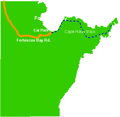
The return walk to Cape Hauy is approximately 10 k's and can be completed in 4 hours but to enjoy the spectacular coastal scenery you would be advised to allow a longer period.  This area features the tallest sea cliffs in the Southern Hemisphere at over 300 metres, and this walk provides the opportunity to view them first hand....awesome! The walk is graded medium and consists of mainly narrow but distinct tracks which can be muddy in parts. A reasonable level of fitness is required to undertake this walk. 


On a world scale this area is very unique.....the gigantic columns and cliffs at Cape Hauy are composed of Jurassic Dolerite...the most extensive of all dolerite formations worldwide are found in Tasmania. The striking 'Organ Pipes' of Mt Wellington, looming over Hobart, are dolerite as too is Mt Ossa (Tasmania's highest peak), Mt Olympus and the jagged peaks of Cradle Mountain, and much else of eastern, southern and central Tasmania.


To access the track turn left off the Arthur Highway 3.5km south of the junction at Taranna onto a gravel forestry road marked 'Fortescue Bay Camping Area 12km'. Follow the signs for the next 12km to Fortescue Bay and park in the Casuarina Day Use Area. Fortescue Bay is a sheltered inlet on the eastern side of the Peninsula.  The long, sheltered beach, unspoiled views, and tranquil waters make it one of the most beautiful places on the peninsula. 


As this walk is in the Tasman National Park, park entry fees apply. A Tasmania Parks and Wildlife pass will need to be purchased from the Ranger on site...the cost of the passes range from $12.00 for a 24 hour pass up to $123.00 for 2 years entry. The track is accessed just near the boat ramp where there is a sign marked 'Cape Hauy Track 4 hours return'.


The track follows the rocky shore for about 15 minutes walk then climbs southeast. After approximately 30 minutes the track turns south away from the coast and after a short level section climbs steeply into dry sclerophyll forest (vegetation that has hard leaves and short internodes....the distance between the leaves along the stem). The track now passes through two rather wet areas of low scrub.  After about an hours walk the track climbs onto a low spur and reaches a sign marked 'Cape Pillar via Mt Fortescue' pointing to the right.


It was at this junction we decided to have a morning tea break. Newly refreshed we follow the track as it descends steeply onto the Cape.  The vegetation from now on consists of low coastal heathland with many flowering species.


The route crosses a saddle and there are extensive views both north to the Forestier coast and Maria Island, and south to Cape Pillar, with the Blade clearly silhouetted against the sky.  Unfortunately, due to the drizzly conditions we didn't get the extensive views that are visible on a clear day, however what we could see was still spectacular. 


First View of the Cape


Natural Arch at base of cliffs

Looking back while climbing to the next ridge it is possible to see a natural arch where the sea has undermined the base of the towering cliffs.
From the ridge with its view of Hippolyte Rock beyond the Cape, the track descends to pass a deep sinkhole on the left. A sinkhole is a natural depression or hole in the Earth's surface caused by the dissolution of a layer or layers of bedrock.  Unfortunately, I was unable to take a clear photo of the sinkhole as I wasn't able to summon up the courage to get close enough to take a decent shot or to have a good look inside it. However, anyone who is more adventurous than me and manages to get within close proximity will notice that because of its depth, the bottom is sheltered and has created an environment which supports vegetation quite different from the surrounding heathland. There are Treeferns and other wet forest species growing there.

Now the fun begins! The track from now on never deviates far from the steep, unguarded cliff edge, and with the gusty winds prevailing its cause on occasion for some hairy moments, especially for Jane who is slight of build...not quite such a problem for me! Needless to say the views of rock outcrops and small islands are nothing short of spectacular.


The track eventually reaches a sign warning walkers that the track ends after a further 50 metres.  While this may be true, it is possible to proceed on further down a steep descent to enable a glimpse of the unique rock formation known as the Candlestick, which rises vertically from the sea. The Candlestick stands next to the end of the Cape clearly visible just next to the spot we chose to have lunch and behind it are the sea stacks known as The Lanterns. While the Totem Pole, another large dolerite column rising out of the sea, is not visible at this level it is possible to scramble down to within a few metres of the water for a better view.  Be warned....this is extremely dangerous as the descent is over steep loose rock...with this in mind Jane and I decided against going any further. 


These sea stacks are popular for climbing and abseiling.  The Candlestick is 112m high while the Totem Pole stands at 60 metres with a diameter of only about 4m. According to the Climbing Club of Tasmania website access to both stacks is by abseiling to the base of the Cape (approx. 60 m)  More Climbing Info

Take a look at this photo of a climber on the Totem Pole...not for the novice or the faint hearted.


As mentioned earlier we find a great little spot on the top of the Cape to have our lunch...overlooking the picturesque Forestier Coast with the added bonus of a large number of dolphins playing in the bay...just fantastic, wonder what the poor people are doing for lunch today!


The return trip to Fortescue Bay was fairly uneventful, although there were several other walkers on the track, we encountered 25 for the day.  Of the walks completed so far I would consider this one to be the most spectacular as far as the scenery goes....it is just magnificent.  The walk itself is not hard as the track is well formed and easily traversed, there are several steep areas but nothing anyone with a reasonable level of fitness would find challenging.


Although at relatively low-altitude, allowing year-round bushwalking on the Peninsula, south-westerly weather changes can suddenly roar across Storm Bay bringing rain, hail, and a drastic drop in temperature, even in the summer months, so it is wise to be prepared.  When we completed this walk the forecast for Hobart was 21 degrees and fine, however we encountered wet, cold and windy conditions. It is recommended that walkers are equipped with sturdy footwear, such as boots or non-slip runners, carry sufficient drinking water, spare food, clothing, sun-hats, sun-screen, wet-weather gear, first-aid kit, maps and other necessities.  It is essential to also exercise extreme caution where there are unguarded lookouts with high drops, cliffs with loose or crumbling edges, blow-holes, or slippery inclines. I would be reluctant to take young children on this walk unless prepared to be very vigilant and keep them under constant supervision.


While this is a four hour return walk, as advised earlier,  it is worth allowing longer so as to enjoy the stunning surrounds.  We left the camping ground at 10.00am and returned at 4.00pm, which allowed for numerous photo stops and a leisurely lunch.


If you only manage to complete one walk on the Peninsula (and I hope it is more than this) I would highly recommend you consider undertaking the walk to Cape Hauy...I know you will find it truly inspiring, just as Jane & I did.


A few more shots of what you will see along the way.

Candlestick


 Totem Pole, Candlestick & Lanterns from the sea

Saturday, February 19, 2011

Walk Number 4....Fazackerleys Range Circuit 14/2/2011

Valentine's Day, a day on which lovers express their love for each other, a day to receive a card or flowers from a secret admirer, and a day for Jane and I to venture out and explore unknown territory..that being the Fazackerleys Range Circuit.


To access this area we turned east off the Arthur Highway, 5.2km south of Murdunna into a forestry road with a sign marked 'Forestier State Forest'.  We then drove 1.9km to a forestry gate, it was here that we parked the car and began our trek.


Both Jane and I started off enthusiastically, eager to get to the first landmark being the MacGregor Fire Tower. Our enthusiasm waned very quickly after starting the 30 minute walk.  The track was very steep and very rocky, infact exceedingly steep and rocky!  I was thinking about how many hours on the treadmill I'd need to get a cardio workout like this one and Jane was thinking, as she later admitted, what sort of walk is this mad woman taking me on.  Needless to say there was not much talking done for the next half hour, neither of us had any breathe left to waste on talking.  This was hard yakka!


Finally, we reach flat ground....ahh relief...not for long though as the track now narrows and climbs steeply, but for only about 100 metres to the Fire Tower.


From the upper levels of the firetower there are extensive views which sweep from Maria Island in the north across Blackman and Norfolk Bays, away to Mount Wellington and Adamsons Peak in the west, then on to Capes Pillar and Hauy in the south. Closer at hand are the rugged cliffs above Waterfall Bay and the sheltered anchorage of Pirates Bay.  Unfortunately it isn't possible to climb to the top level of the tower, but good views can be had from the next level down. The MacGregor Tower is 461 metres above sea level.


From the firetower the walking track heads east and is marked by a mixture of orange pointers and small rock cairns. Unfortunately the pointers are very infrequent and at times hard to spot so looking out for them does detract a little from appreciating the beautiful surrounds. This area is dominated by Stringbark and Blue Gum, scattered Bedfordia and a few patches of young Sassafras.  The track which is over rocky ground swings southeast and enters a closed forest (a forest with a tree canopy of 60 to 100%). For the first time on any of my walks we come across a black snake...minding his own business sunning himself on the track. Under the circumstances all 3 of us remained relatively calm, the snake slithered away under a rock and Jane and I took a wide berth around the area just in case. After this encounter we were mindful of the need to remain on alert for unexpected wildlife sharing the track.


The route continues to an area locally know as the Magic Forest and it's not difficult to see why.  The track winds through a very old forest of Sassafras, Musk and Native Laurel, which have gnarled and twisted trunks and branches, while Treeferns and the endemic Grass Trees grow among large moss covered rocks.  Funghi of all shapes, sizes and colours grow on the ground and fallen logs, and even on the living trees.  The whole scene is bathed in an almost iridescent green light...it is truly magical.


The track at this point is dominated by alot of boulder climbing which once again gets the heart rate up.  Another thing I noticed as we were walking along, probably because I was leading the way, is there are so many spider webs...now this doesn't normally worry me but walking through thick webs every few metres can get a bit freaky, I was starting to get paranoid as to whether the occupants of these webs were using me as some sort of free public transport service...regular checks found this wasn't the case...thank goodness!


One hour from the firetower the track reaches a trig point at the true summit of MacGregor Peak, 591 metres above sea level, it's here that we stop for our first prolonged refreshment break.


A few metres to the south of the trig marker, a large rock provides views to Tasman Island, Cape Pillar, Hippolyte Rock, Cape Hauy and Norfolk Bay.  This is the premium spot on the hike for scenic vistas.


Cape Pillar, Hippolytes & Cape Hauy

Pirates Bay

Jane getting a few shots
From MacGregor Peak the route heads northeast, descending from the rocky summit and following the ridge of the Fazackerleys Range.  It is marked with a mixture of orange pointers and various coloured tapes.  We noticed that the ferns were quite thick and overgrowing the track so if you're not wearing gaiters expect to get a few scratches. 


We follow the track for another 25 minutes or so and then it descends off the ridge and enters the largest tract of remnant rainforest on the east coast.  This is a truly impressive forest, being dominated by massive Sassafras and Musk, the occasional Celery-top Pine and some of the largest Treeferns on the Peninsula.  The ground is a mass of twisted roots, and mosses and ferns grow abundantly.  A word of caution though, the markers become very unclear and very intermittent.....we spent a lot of time getting through this area.  In the name of safety do not proceed on until you have sighted the next marker as the track is very unclear and it would be very easy to become disoriented and ultimately lost....unless that's just me!  How we approached this situation was for one of us to stay at the last known marker while the other went in search of the next marker.....never wandering too far away, always in a straight line and always staying within ear shot of the other person. For this reason alone it would be very foolish to go on any of these walks by yourself....at this point we had also lost mobile reception.


The descent off the ridge is, as expected, very steep and is through mixed forest.  Mixed forest is a type of Cool Temperate Rainforest, where trees grow as an understorey amongst old growth giants, it is very rare and only occurs in areas that have not had fire for a very long time.  Unfortunately, there are signs of old selective logging activity, with some very large old stumps and the remains of a shoe track where logs were dragged across the forest floor.


Approximately an hour from the summit, the walking track intersects the four wheel drive track "Schofields Road".  It's at this point we stop for lunch.  It wasn't the most relaxing lunch spot, as there was the constant need to check ourselves for leeches which seemed to be quite abundant in this area.

Once we finish lunch we head down the 4WD track through regrowth wet forest...wet forest has an understorey in which broad-leaved tall shrubs and small trees such as Dogwood, Musk and Bedfordia form a prominent layer. The shrub understorey is often very dense.  After a 25 minute walk we come to a forestry gate, which isn't very obvious as quite a bit of foliage has grown over it and obscured it from view. Just beyond the gate is a jeep track which leads to the left.  Follow this track as it climbs (quite steeply) to a saddle in the Fazackerleys Range. Apparently, the track passes an old quarry site, however we didn't spot it so can only conclude that it has been many, many years since it's been worked and has now become overgrown.

After a further 30 minute walk we reach another forestry gate and lo and behold end up at the spot where we left the car 6 and a half hours earlier! So, the Fazackerleys Range Circuit had been successfully completed, taking longer than anticipated, due mainly to the condition of the track and the need to be sure of keeping on the correct route.  While we didn't experience the breathtaking views that have been a feature of previous hikes, this one held it's own allurement by passing through some of the most breathtaking scenery you could wish to encounter.  Researching the different types of forests and their makeup has also appealed to my inner geek...I'm learning so much, and hope that the readers of this blog find the little bits of info interesting as well.


Well, I have managed to return another walking partner safely back to civilisation, and Jane has even expressed an enthusiastic interest in accompanyng me on another hike in the future...yay! Not sure if she was swayed by the obligatory refreshment break at the Dunalley pub on the way home, or the mutual enjoyment we shared from spending the day in such a magnificent location, but I will definitely be taking her up on the offer.

So once again a day has been spent in magnificent surrounds and with a fantastic walking companion.  Bushwalking should be fun, so when you set out don't put pressure on yourself to achieve the times given on signs and don't be afraid to turn back if the walk seems too difficult.  We are blessed with some of the most beautiful scenery in the State and I'm sure if you decide to undertake these walks you will find them, like I have, to be irresistable!

I can't think of any better way to have spent Valentine's Day......well perhaps there's one other better way but this comes in at a very close second!!


Giant Treefern


Thursday, February 10, 2011

Planning the 4th walk & information about the Peninsula

Amazingly, another unsuspecting friend has, of her own free will, volunteered to let me lead her on a hike into unknown territory. This time my walking companion is Jane, an ex work colleague, who is keen to experience a jaunt around the Peninsula.


Monday 14th February, being a public holiday in Hobart, is the chosen date and the chosen destination is the Fazackerleys Range Circuit.  This walk is of medium grade meaning suitable for walkers of average fitness, on a marked track or route, some of which may be rough or overgrown.  There can be long steep gradients and there are natural obstacles such as rocks and fallen logs to negotiate. According to the guide book this walk should take around 4 hours for the round trip.  


The Fazackerley Range Circuit gives the walker the opportunity to examine samples of various forest types, including the largest tract of remnant rain forest on the east coast of Tasmania.  There are also two lookouts providing breathtaking scenery.


Roll on Monday!!


History Lesson


I realised recently that as part of this blog there should be a detailed description of the peninsula...it's general location, the history of the area and local attractions. While the area is familiar to most Hobartians, people living further afield wouldn't know a lot about the area other than perhaps Port Arthur is located there.


The Tasman Peninsula is located at the south east corner of Tasmania around 75km by road from Hobart.  The Peninsula lies south and west of Forestier Peninsula, to which it is connected by an isthmus called Eaglehawk Neck.  This in turn is joined to the rest of Tasmania by an isthmus called East Bay Neck, near the town of Dunalley, about 60km by road from Hobart.
 File:Tasman Peninlsula map.png

Although the area is named after Dutch explorer Abel Tasman, the aboriginal inhabitants of this area preceding European arrival were the Pydairrerme people. Their territory was what is now known as the Tasman and Forestier peninsulas.


The first European settlement of the Peninsula was Port Arthur in the early 1830s. It was selected as a penal settlement because it was geographically isolated from the rest of the colony but more easily reachable by sea than the other place of secondary banishment, Macquarie Harbour on the west coast, which could then be closed down. It also had excellent supplies of timber for shipbuilding and general construction work, and a deep sheltered harbour where visiting British warships could be repaired. Its inaccessibility was enhanced by having Eaglehawk Neck lined with guards and guard dogs, to prevent the escape of any convicts. A small number did escape, including the notorious bushranger Martin Cash.


The Saltwater River historic site, located near the north tip west of the peninsula, was originally the site of a convict-operated coal mine.
The penal settlement of Port Arthur is now a tourist attraction. As in most of the rest of the state, tourism is a major industry. Bushwalking is also popular in the often rugged terrain, particularly picturesque spots being Cape Raoul and Cape Pillar at the extreme south west and south east ends of the Peninsula, separated by the entrance to Port Arthur.

While the area is best known for its convict history it is now the key area in the battle to save the Tasmanian Devil from extinction from a type of contagious cancer called Devil facial tumour disease (DFTD).

The isolation from the Tasmanian mainland, where DFTD is running unchecked and has killed more than half of all devils, is ideal for maintaining a healthy wild Tasmanian Devil population in a project that involves the local Tasmanian Devil Conservation Park at Taranna and government and university scientists.
The Tasman Peninsula is well known for its rugged eastern coastline, and much of it is now the Tasman National Park. At Eaglehawk Neck there are many strange rock formations, including Devil's Kitchen, Tasman'a Arch, Blow Hole and Tessellated Pavement.  Further south are the highest sea cliffs in the southern hemisphere rising 300 m above the Tasman Sea at Cape Hauy. The Peninsula is claimed to have some of Australia's best surf spots at Cape Raoul, Roaring Beach and Shipstern Bluff (walk number 2).
File:Cape Raoul from Lookout.jpg
Cape Raoul

File:The Totem Pole, Cape Huay.jpg
Cape Hauy