Thursday, June 30, 2011

Walk Number 16.......Mount Stewart

It's the Queen's Birthday long weekend holiday and all my usual walking partner's are away enjoying the extra day off.  I've packed up and headed to the shack with my son Riley to enjoy a bit of R & R, and to do a little walk (his idea, not mine). After having looked through the walks book we decided on a walk that was graded as a family walk, which we thought was quite appropriate for a mother and son team.


Mount Stewart is our chosen destination, it's situated not far from the Coal Mines Historic Site at Saltwater River. Turn off the Arthur Highway onto the B37 road just south of the Tasmanian Devil Park at Taranna.  Travel for approximately 9km and turn right onto the C341 Saltwater River Road near The Old Trading General Store at Premaydena.  Follow this road for 9.7km to an intersection, turn right into Coalmines Road and drive 3.3km into the Coalmines Reserve, to a road on the left marked 'Air Shaft'. Follow this road for 200 metres to a car park near the start of a fire trail marked 'Vehicular Access Prohibited'. The walk starts here.


Follow the fire trail through the low headland which has a wide variety of plants many of which were out in flower at this time of year.


The track intersects with a firebreak after about 5 minutes walking. Turn right and follow a fenceline for a further 200 metres to another junction and turn left.  Walk for only 40 metres to where a set of wheel tracks lead off to the right....this is not clearly obvious so be on the lookout.


Follow the wheel tracks through dry sclerophyll forest in a general northerly direction onto the slopes of Mount Stewart, eventually climbing more steeply through young Silver Wattles onto the summit.  Along the way there are some fantastic examples of the funghi which surprisingly Riley found very interesting....a boy after my own heart.


At the summit there are some remains of the old signal station used as part of a chain to send semaphore messages between Port Arthur and Hobart in the convict period.  This is just one of the things i love about the Peninsula...you can just stumble across these little patches of history without any fanfare or hoopla....it's just sitting there waiting for you to find it.


Now another fact which Riley (and I) found so interesting is that the bare rocky summit of Mount Stewart is the tube of an ancient volcano, the cone having been eroded long ago.....this fact provided quite an in depth conversation about volcanoes in Tasmania, the chances of them re-erupting and so on.  Fabulous when a 14 year old's imagination goes riot!


From this vantage point there are views over the Reserve to Lime Bay, Sloping Lagoon, Lagoon Beach and Sloping Island.  Further west, South Arm and Bruny Island can be seen whilst Mt Wellington and the Southern Mountains dominate the horizon. When you've finished admiring the views return to  your car by the same route.


Really enjoyed this walk as it was the first one I'd done with one of the kids....and i didn't have to frog march him into it.  The good thing was he really got involved with the surroundings and was even pointing things out to me...and even suggested we do another one together sometime.


This walk is a good one to introduce kids to the experience of bush walking....a little challenging without being too hard to scare them off.




Thursday, June 9, 2011

Walk Number 15....Crescent Beach and Mount Brown 29/5/2011

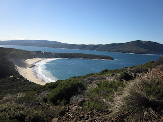
Wow, how things change....have gone from not doing a walk in almost 6 weeks to doing 3 in 9 days! Jane & I set out bright and early (7.00am) on a very brisk but clear Sunday morning to head to the Peninsula to walk into Crescent Bay....a perfect white crescent of sand backed by high dunes, only accessible by boat or on foot.  The first time I walked into this bay was back in late December and it was the walk that provided the catalyst for me to undertake this little project I have set for myself.  On that occasion I walked in via the short route, through private property and over the sand dunes....check out walk number 1 for details.


Today I have chosen to do the much longer route (10km return), which is more spectacular, taking in Maingon Blowhole, a beautiful rocky shoreline and Mount Brown along with the sand dunes of the bay and the blowholes of Standup Point.


Access to the track is via the Arthur Highway, past the entrance to the Port Arthur Historic Site, onto the C347 road to Remarkable Cave.  Drive the 5km to the Cave carpark and the walk back along the road about 100 metres to a sign on the right, giving walking times.


Take a few minutes before setting off on the track to take in the sensational scenery of this area....it has a real wow factor.


Initially the track climbs uphill then crosses a series of low ridges. An interesting fact is that these ridges are actually vegetated sand dunes which were formed during the last ice age, when sea levels were much lower and strong southwesterlies deposited sand from what is now the sea bed into these formations...how about that!


The vegetation on the track at this point is low coastal heath and is very exposed to the elements, however we were very fortunate to pick a day of next to no wind so the conditions were very pleasant but I can imagine that it would get very harsh at times.


After 30 minutes walking the track approaches Maingon Blowhole which has a warning sign just before you get to it, and is very justified. It is a narrow slit in the earth which drops a rather large distance into a sliver of white water below. Care should be taken when inspecting the blowhole as the edges are steep and crumbling.


The track now swings inland towards Mt Brown and crosses a shallow valley before climbing onto the lower slopes where you get the first views of Crescent Beach. About 20 minutes on from Maingon Blowhole there is a rock cairn which marks the start of the side trip to the summit of Mt Brown.  Jane & I decided to continue on to the beach & do the walk up the mountain on our return.


The descent down to the bay affords you some of the most magnificent views to Tasman Island and Cape Pillar.


Once down onto the beach the steep dunes are too tempting to ignore and a very arduous climb up is rewarded with a fun slide down!


At the far end of the beach is Standup Point, which has its own blowholes. In heavy seas they apparently blow quite spectacularly, but access would be more difficult and dangerous.


On the return trip we ventured up Mt Brown which although a steep climb wasn't too difficult. The views from the top are great; Crescent Bay, Port Arthur, Cape Pillar, Tasman Island and Cape Raoul make a dramatic 360 degree vista.


The walk in total, taking into account refreshment & photo breaks, took us close to 6 hours to complete.  If you want to undertake a longer walk which isn't too hard but takes in some fantastic scenery this is the one for you.  If you're lucky enough to chose a great day weather wise like us, you will not be disappointed.....highly recommend this one.