Monday 14th February, being a public holiday in Hobart, is the chosen date and the chosen destination is the Fazackerleys Range Circuit. This walk is of medium grade meaning suitable for walkers of average fitness, on a marked track or route, some of which may be rough or overgrown. There can be long steep gradients and there are natural obstacles such as rocks and fallen logs to negotiate. According to the guide book this walk should take around 4 hours for the round trip.
The Fazackerley Range Circuit gives the walker the opportunity to examine samples of various forest types, including the largest tract of remnant rain forest on the east coast of Tasmania. There are also two lookouts providing breathtaking scenery.
Roll on Monday!!
History Lesson
I realised recently that as part of this blog there should be a detailed description of the peninsula...it's general location, the history of the area and local attractions. While the area is familiar to most Hobartians, people living further afield wouldn't know a lot about the area other than perhaps Port Arthur is located there.
The Tasman Peninsula is located at the south east corner of Tasmania around 75km by road from Hobart. The Peninsula lies south and west of Forestier Peninsula, to which it is connected by an isthmus called Eaglehawk Neck. This in turn is joined to the rest of Tasmania by an isthmus called East Bay Neck, near the town of Dunalley, about 60km by road from Hobart.

Although the area is named after Dutch explorer Abel Tasman, the aboriginal inhabitants of this area preceding European arrival were the Pydairrerme people. Their territory was what is now known as the Tasman and Forestier peninsulas.
The first European settlement of the Peninsula was Port Arthur in the early 1830s. It was selected as a penal settlement because it was geographically isolated from the rest of the colony but more easily reachable by sea than the other place of secondary banishment, Macquarie Harbour on the west coast, which could then be closed down. It also had excellent supplies of timber for shipbuilding and general construction work, and a deep sheltered harbour where visiting British warships could be repaired. Its inaccessibility was enhanced by having Eaglehawk Neck lined with guards and guard dogs, to prevent the escape of any convicts. A small number did escape, including the notorious bushranger Martin Cash.
The Saltwater River historic site, located near the north tip west of the peninsula, was originally the site of a convict-operated coal mine.
The penal settlement of Port Arthur is now a tourist attraction. As in most of the rest of the state, tourism is a major industry. Bushwalking is also popular in the often rugged terrain, particularly picturesque spots being Cape Raoul and Cape Pillar at the extreme south west and south east ends of the Peninsula, separated by the entrance to Port Arthur.
While the area is best known for its convict history it is now the key area in the battle to save the Tasmanian Devil from extinction from a type of contagious cancer called Devil facial tumour disease (DFTD).
The isolation from the Tasmanian mainland, where DFTD is running unchecked and has killed more than half of all devils, is ideal for maintaining a healthy wild Tasmanian Devil population in a project that involves the local Tasmanian Devil Conservation Park at Taranna and government and university scientists.
The Tasman Peninsula is well known for its rugged eastern coastline, and much of it is now the Tasman National Park. At Eaglehawk Neck there are many strange rock formations, including Devil's Kitchen, Tasman'a Arch, Blow Hole and Tessellated Pavement. Further south are the highest sea cliffs in the southern hemisphere rising 300 m above the Tasman Sea at Cape Hauy. The Peninsula is claimed to have some of Australia's best surf spots at Cape Raoul, Roaring Beach and Shipstern Bluff (walk number 2).

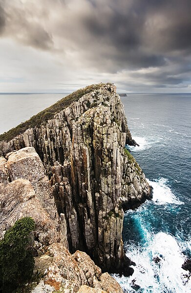
Cape Hauy
Love the blog Karen ! I am especially enjoying the history & photos. I never knew Martin Cash escaped from Port Arthur Penal Colony - wow. I love Tassie and do trips all over the place every time I come home. I wish I were there to do some of these walks with you ! Will enjoy the blog instead =)
ReplyDeleteWell done Mrs Meredith.....great comments on history, geography and sociology like Wis said. Would love to look at it sometime....:)
ReplyDelete