The return walk to Cape Hauy is approximately 10 k's and can be completed in 4 hours but to enjoy the spectacular coastal scenery you would be advised to allow a longer period. This area features the tallest sea cliffs in the Southern Hemisphere at over 300 metres, and this walk provides the opportunity to view them first hand....awesome! The walk is graded medium and consists of mainly narrow but distinct tracks which can be muddy in parts. A reasonable level of fitness is required to undertake this walk.
On a world scale this area is very unique.....the gigantic columns and cliffs at Cape Hauy are composed of Jurassic Dolerite...the most extensive of all dolerite formations worldwide are found in Tasmania. The striking 'Organ Pipes' of Mt Wellington, looming over Hobart, are dolerite as too is Mt Ossa (Tasmania's highest peak), Mt Olympus and the jagged peaks of Cradle Mountain, and much else of eastern, southern and central Tasmania.
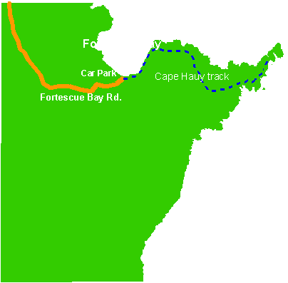
To access the track turn left off the Arthur Highway 3.5km south of the junction at Taranna onto a gravel forestry road marked 'Fortescue Bay Camping Area 12km'. Follow the signs for the next 12km to Fortescue Bay and park in the Casuarina Day Use Area. Fortescue Bay is a sheltered inlet on the eastern side of the Peninsula. The long, sheltered beach, unspoiled views, and tranquil waters make it one of the most beautiful places on the peninsula.
 As this walk is in the Tasman National Park, park entry fees apply. A Tasmania Parks and Wildlife pass will need to be purchased from the Ranger on site...the cost of the passes range from $12.00 for a 24 hour pass up to $123.00 for 2 years entry. The track is accessed just near the boat ramp where there is a sign marked 'Cape Hauy Track 4 hours return'.
The track follows the rocky shore for about 15 minutes walk then climbs southeast. After approximately 30 minutes the track turns south away from the coast and after a short level section climbs steeply into dry sclerophyll forest (vegetation that has hard leaves and short internodes....the distance between the leaves along the stem). The track now passes through two rather wet areas of low scrub. After about an hours walk the track climbs onto a low spur and reaches a sign marked 'Cape Pillar via Mt Fortescue' pointing to the right.


The route crosses a saddle and there are extensive views both north to the Forestier coast and Maria Island, and south to Cape Pillar, with the Blade clearly silhouetted against the sky. Unfortunately, due to the drizzly conditions we didn't get the extensive views that are visible on a clear day, however what we could see was still spectacular.
First View of the Cape

 |
| Natural Arch at base of cliffs |
From the ridge with its view of Hippolyte Rock beyond the Cape, the track descends to pass a deep sinkhole on the left. A sinkhole is a natural depression or hole in the Earth's surface caused by the dissolution of a layer or layers of bedrock. Unfortunately, I was unable to take a clear photo of the sinkhole as I wasn't able to summon up the courage to get close enough to take a decent shot or to have a good look inside it. However, anyone who is more adventurous than me and manages to get within close proximity will notice that because of its depth, the bottom is sheltered and has created an environment which supports vegetation quite different from the surrounding heathland. There are Treeferns and other wet forest species growing there.
Now the fun begins! The track from now on never deviates far from the steep, unguarded cliff edge, and with the gusty winds prevailing its cause on occasion for some hairy moments, especially for Jane who is slight of build...not quite such a problem for me! Needless to say the views of rock outcrops and small islands are nothing short of spectacular.


The track eventually reaches a sign warning walkers that the track ends after a further 50 metres. While this may be true, it is possible to proceed on further down a steep descent to enable a glimpse of the unique rock formation known as the Candlestick, which rises vertically from the sea. The Candlestick stands next to the end of the Cape clearly visible just next to the spot we chose to have lunch and behind it are the sea stacks known as The Lanterns. While the Totem Pole, another large dolerite column rising out of the sea, is not visible at this level it is possible to scramble down to within a few metres of the water for a better view. Be warned....this is extremely dangerous as the descent is over steep loose rock...with this in mind Jane and I decided against going any further.
 These sea stacks are popular for climbing and abseiling. The Candlestick is 112m high while the Totem Pole stands at 60 metres with a diameter of only about 4m. According to the Climbing Club of Tasmania website access to both stacks is by abseiling to the base of the Cape (approx. 60 m) More Climbing Info
Take a look at this photo of a climber on the Totem Pole...not for the novice or the faint hearted.
As mentioned earlier we find a great little spot on the top of the Cape to have our lunch...overlooking the picturesque Forestier Coast with the added bonus of a large number of dolphins playing in the bay...just fantastic, wonder what the poor people are doing for lunch today!

The return trip to Fortescue Bay was fairly uneventful, although there were several other walkers on the track, we encountered 25 for the day. Of the walks completed so far I would consider this one to be the most spectacular as far as the scenery goes....it is just magnificent. The walk itself is not hard as the track is well formed and easily traversed, there are several steep areas but nothing anyone with a reasonable level of fitness would find challenging.
Although at relatively low-altitude, allowing year-round bushwalking on the Peninsula, south-westerly weather changes can suddenly roar across Storm Bay bringing rain, hail, and a drastic drop in temperature, even in the summer months, so it is wise to be prepared. When we completed this walk the forecast for Hobart was 21 degrees and fine, however we encountered wet, cold and windy conditions. It is recommended that walkers are equipped with sturdy footwear, such as boots or non-slip runners, carry sufficient drinking water, spare food, clothing, sun-hats, sun-screen, wet-weather gear, first-aid kit, maps and other necessities. It is essential to also exercise extreme caution where there are unguarded lookouts with high drops, cliffs with loose or crumbling edges, blow-holes, or slippery inclines. I would be reluctant to take young children on this walk unless prepared to be very vigilant and keep them under constant supervision.
While this is a four hour return walk, as advised earlier, it is worth allowing longer so as to enjoy the stunning surrounds. We left the camping ground at 10.00am and returned at 4.00pm, which allowed for numerous photo stops and a leisurely lunch.
If you only manage to complete one walk on the Peninsula (and I hope it is more than this) I would highly recommend you consider undertaking the walk to Cape Hauy...I know you will find it truly inspiring, just as Jane & I did.
A few more shots of what you will see along the way.
 |
| Candlestick |


 |
| Totem Pole, Candlestick & Lanterns from the sea |
Just walked to Cape Hauy for the first time this week - spectacular! In fact, I think I may go for another walk there today.
ReplyDeleteyes, it sure is fantastic....probably my favorite walk, did it again a couple of weeks ago
ReplyDeleteYes, it's my favourite on the Peninsula as well, so far. I went there yesterday again (second time). I'm posting some photos on Google+ if you're interested; you can find them at this link (I think it's correct):
ReplyDeletehttps://plus.google.com/105467608874315931098/posts
:)
wow, fantastic pics! Obviously you have more than just a passing interest in photography
ReplyDeleteJust a hobby; learning new skills and techniques all the time. I'm lucky to live in such a beautiful place.
ReplyDelete